




What El Niño Is Doing to Shape NOAA’s Latest Winter Outlook
 November 4, 2026
The recently released U.S. Winter Outlook from NOAA indicates El Niño will play a big role in how the upcoming winter season will play out. This is not a surprise. The infamous climate phase has been making headlines since the spring, as its development has come on swiftly and extremely strongly. By the time it’s all said and done, this El Niño event could be the strongest on record.
Its influence on the Atlantic hurricane season has been record-breaking — for lack of tropical activity. The one and only hurricane in the Atlantic basin so far (Hurricane Isaias) occurred this month. Waiting that long for the season’s first hurricane to form has never happened — at least not since the modern satellite era. On the other hand, there has been a glut of hurricane activity in the eastern Pacific. So, as hurricane season winds down, what will our El Niño winter look like? Let’s find out.
According to NOAA climatologists, December 2026 through February 2027 will feature warmer-than-average temperatures across the northern U.S.; likely wetter-than-average conditions across the southern U.S., from California to Florida, and along the Eastern Seaboard; and improved drought conditions for the majority of the country.
Here are the main takeaways from NOAA’s Winter Outlook.
Temperature Checks
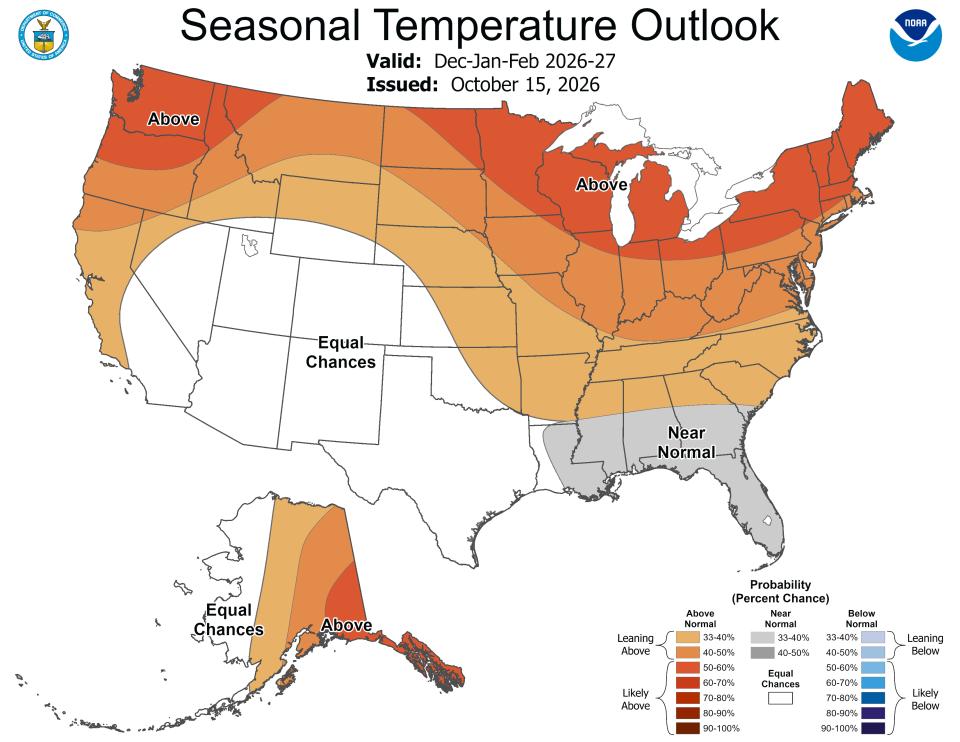
Winter 2027 temperature outlook map. | NOAA
- Warmer-than-average temperatures are favored for northern California, the Pacific Northwest, the Midwest, the Mississippi Valley, much of the East, Alaska, and for Puerto Rico/U.S. Virgin Islands.
- Near-normal temperatures are most likely for parts of the Southeast, including Florida.
- Hawaii and much of the Southwest have equal chances of below-average, near-average, or above-average seasonal mean temperatures.
Precipitation Predictions
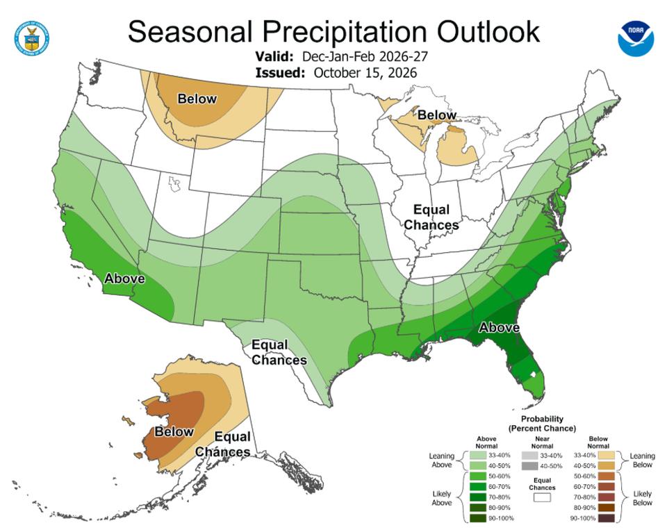
Winter 2027 precipitation outlook map. | NOAA
- Wetter-than-average conditions are most likely across the southern tier, from the Southwest to the Southeast, and along the East Coast.
- Elevated odds for drier-than-average conditions for Hawaii, much of Alaska, the northern Mountain West, some areas in the Great Lakes, and the western Pacific Islands.
- Areas in the Intermountain West, northern Plains, Ohio Valley, and Puerto Rico/U.S. Virgin Islands have equal chances of below-average, near-average, or above-average seasonal total precipitation amounts.
Looking Ahead
El Niño is expected to hold on as the dominant climate phase until at least February 2027. A gradual transition back to neutral is expected thereafter, according to NOAA climate forecast data. The neutral climate phase is then expected to be in charge starting sometime in the spring.
Subscribe to eNewsletter